We stand behind every sale with a 100% Customer Satisfaction Guarantee.
If you are not completely satisfied with your purchase for any reason, return your order to us in the original packaging within 30 days of receipt and we will give you a full refund of your product costs or issue a free replacement of a damaged product in transit to you.
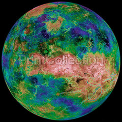
The hemispheric view of Venus, as revealed by more than a decade of radar investigations culminating in the 1990-1994 Magellan mission, is centered at 90 degrees east longitude. The Magellan spacecraft imaged more than 98% of Venus at a resolution of about 100 meters; the effective resolution of this image is about 3 km. A mosaic of the Magellan images (most with illumination from the west) forms the image base. Gaps in the Magellan coverage were filled with images from the Earth-based Arecibo radar in a region centered roughly on 0 degree latitude and longitude, and with a neutral tone elsewhere (primarily near the south pole). The composite image was processed to improve contrast and to emphasize small features, and was color-coded to represent elevation. Gaps in the elevation data from the Magellan radar altimeter were filled with altimetry from the Venera spacecraft and the U.S. Pioneer Venus missions. An orthographic projection was used, simulating a distant view of one hemisphere of the planet. The Magellan mission was managed for NASA by Jet Propulsion Laboratory (JPL), Pasadena, CA. Data processed by JPL, the Massachusetts Institute of Technology, Cambridge, MA, and the U.S. Geological Survey, Flagstaff, AZ.
Image Credit: NASA/JPL/USGS
Image Addition Date: 1998-06-04
All prints are made with the finest quality Digital Giclée printing using 12 color archival inks. We have chosen a 300gsm Rag Matt finish paper with no "Optical Brightners" to extend the life of your print.
Great care has been taken to reproduce this image for you. We stand behind the quality of your print with a 100% customer satisfaction guarantee.
The hemispheric view of Venus, as revealed by more than a decade of radar investigations culminating in the 1990-1994 Magellan mission, is centered at 90 degrees east longitude. The Magellan spacecraft imaged more than 98% of Venus at a resolution of about 100 meters; the effective resolution of this image is about 3 km. A mosaic of the Magellan images (most with illumination from the west) forms the image base. Gaps in the Magellan coverage were filled with images from the Earth-based Arecibo radar in a region centered roughly on 0 degree latitude and longitude, and with a neutral tone elsewhere (primarily near the south pole). The composite image was processed to improve contrast and to emphasize small features, and was color-coded to represent elevation. Gaps in the elevation data from the Magellan radar altimeter were filled with altimetry from the Venera spacecraft and the U.S. Pioneer Venus missions. An orthographic projection was used, simulating a distant view of one hemisphere of the planet. The Magellan mission was managed for NASA by Jet Propulsion Laboratory (JPL), Pasadena, CA. Data processed by JPL, the Massachusetts Institute of Technology, Cambridge, MA, and the U.S. Geological Survey, Flagstaff, AZ.
Image Credit: NASA/JPL/USGS
Image Addition Date: 1998-06-040
stars, based on 0
reviews1699
166545510PRT-008x010x000-PIA00158.1Hemispheric View of Venushttp://printcollection.com/cdn/shop/products/hemispheric-view-of-venus_large.jpeg?v=1482569453https://printcollection.com/products/hemispheric-view-of-venus16.99USDPrintCollection6059342InStockAll PrintsAviationNASANASAPhotographySpace1deny